Research Tip – Measuring Land
In America, there are two methods to measure land: metes and bounds and the rectangular survey system.
Metes and Bounds
This system is used in the original thirteen colonies and most Eastern states. The following twenty states use this system to measure land:
Connecticut, Delaware, Georgia, Hawaii, Kentucky, Maine, Massachusetts, New Hampshire, New Jersey, New York, North Carolina, Pennsylvania, Rhode Island, Maryland, South Carolina, Tennessee, Texas, Vermont, Virginia, West Virginia.
This method refers to markers and measurements. For example, “Beginning at a large oak tree and extending north thirty yards to a large rock, then extending west….” Each element of the description of the property boundary typically contains three parts: an object or location, a compass direction, and a distance.
Rectangular Survey System
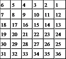
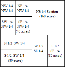
This system of land measurement was first authorized by the Congressional Land Act of 1785 and supplemented by the Federal Land Act of 1796.
| Sections in a Township | Divisions of a Section | ||||||||||||||||||||||||||||||||||||||||||||||||||||||||||||||||||||||||||
 |
 |
||||||||||||||||||||||||||||||||||||||||||||||||||||||||||||||||||||||||||
Some Common Land Measurements |
|||||||||||||||||||||||||||||||||||||||||||||||||||||||||||||||||||||||||||
|
|||||||||||||||||||||||||||||||||||||||||||||||||||||||||||||||||||||||||||
| (All measurements are approximate.) | |||||||||||||||||||||||||||||||||||||||||||||||||||||||||||||||||||||||||||
Last modified: 23-Jun-2016 16:22